
QuikSCAT
Measuring ocean surface winds from space
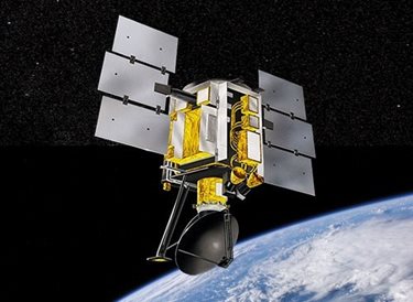
When NASA’s Quick Scatterometer (QuikSCAT) spacecraft launched on June 19, 1999, its SeaWinds instrument made measuring ocean surface winds a breeze. A “quick recovery” mission designed to fill a gap created by the loss of NASA Scatterometer data in 1997, QuikSCAT well outlived its three-year mission requirement, returning valuable science data for nearly two decades.
QuikSCAT’s primary instrument, a specialized microwave radar called SeaWinds, measured near-surface wind speed and direction under all weather and cloud conditions over Earth’s oceans. The SeaWinds scatterometer provided wind-speed measurements over approximately 90 percent of the Earth’s oceans every day.
Ocean surface wind data is used in numerical weather- and wave-prediction models, increasing the accuracy of weather forecasts near coastlines and improving storm warning and monitoring. Data from QuikSCAT contributed to weather forecasts, climate and oceanographic research, land and sea ice studies and more.
NASA QuikSCAT Program Page
Learn more about the science QuikSCAT has gathered over the years on NASA's website
QuikSCAT Feature Story
For nearly two decades QuikSCAT gathered an unprecedented amount of data on our oceans - read more!
What We Did
Instrument and spacecraft provider
As a mission partner to NASA’s Goddard Space Flight Center, we supported construction of the QuickSCAT spacecraft and the integration of the SeaWinds instrument provided by NASA’s Jet Propulsion Laboratory.
To mitigate the data gap between the NASA Scatterometer and QuikSCAT, the QuikSCAT spacecraft was built in 12 months and designed for a three-year mission. The mission lasted for over ten years before the antenna stopped rotating in November 2009. Limited science operations were continued until October 2018 when QuikSCAT was decommissioned. Mission operations for QuikSCAT were led by students and professionals from the University of Colorado (LASP).
To mitigate the data gap between the NASA Scatterometer and QuikSCAT, the QuikSCAT spacecraft was built in 12 months and designed for a three-year mission. The mission lasted for over ten years before the antenna stopped rotating in November 2009. Limited science operations were continued until October 2018 when QuikSCAT was decommissioned. Mission operations for QuikSCAT were led by students and professionals from the University of Colorado (LASP).
Next-Gen Instrument
Smaller Technology. High-Quality Data.
Ball is currently supporting a science team to develop a SmallSat version of the QuikSCAT scatterometer, named Zephyr. While a SmallSat deployment limits the available power, it does provide enough to allow for regional studies of winds, especially along critical coastlines where the wind fields drive ocean upwelling dynamics. Better understanding of these wind fields will help climate modelers to improve their carbon flux exchange estimates between the ocean and atmosphere.